REGIONAL SPECIALIZED METEOROLOGICAL CENTER (BEIJING) FOR ATMOSPHERIC SAND AND DUST STORM FORECASTING
(RSMC-ASDF BEIJING)
SAND AND DUST STORM WARNING ADVISORY AND ASSESSMENT SYSTEM ASIAN REGIONAL CENTER
(SDS-WAS ASIAN-RC)
National-scale unmanned baseline climate station in Songxi, Tibet was officially placed into operation. This station was situated over 5211 meters altitude, becoming the highest altitude national-scale unmanned baseline climate station. After its operation, it will further enrich climate monitoring data in alpine regions of China, optimize integrated meteorological observation layout in Qinghai-Tibet Plateau regions, and provide precious materials for related scientific research.
Songxi national baseline climate station will upload data of 8 meteorological factors ranging from temperature, humidity, air pressure, wind direction, wind speed, precipitation, soil temperature (10cm-50cm) to soil moisture (10cm-50cm). Its establishment will improve integrated meteorological observation layout of Tibet, ramp up monitoring and early warning service capabilities of meteorological disasters, obtain basic meteorological data in specific geographical positions, and provide more accurate decision-making service information for local socio-economic development.
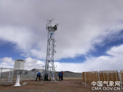
The panorama of the station Photoed by Wu Min
Geared to the adverse climate and transportation conditions in Songxi, this station harnesses advanced digital sensors, and ZigBee wireless transmission technology, with reliable performances and high accuracy. To make sure the consistency of data transmission, this station leverages Beidou satellites and GPRS.
At present, Tibet has 384 ground meteorological stations, which has markedly upgraded integrated meteorological monitoring capabilities.
In the meanwhile, in the following two years, Tibet will strive to realize the full coverage of automatic meteorological stations within county and village territories. (Oct. 29)
Reporter: Zha Ri, Wu Min
Editor: Liu Shuqiao
National Meteorological Centre Copyright © 2018-2020 Beijing ICP 05055842
Powered by the published news, information and a variety of column material without authorization is prohibited download
Maintenance: National Meteorological Centre Forecast System Laboratory
 京公网安备 11040102700101号 京ICP备05055842号-3